A quick summary is available from the Bureau of Meteorology (BOM) regarding the latest long-range climate forecasts to help keep growers informed and prepared in the months ahead.
The BOM has recently highlighted the importance of relying on long-range forecasts, rather than focusing solely on headlines surrounding the possible development of an El Niño event later this year. According to the Bureau, long-range forecasts remain the best guide to Australia’s likely rainfall and temperature patterns, as they take into account the many climate systems influencing weather conditions and are updated regularly as conditions change.
The Bureau also notes that El Niño does not automatically guarantee drought or severe weather impacts across Australia. Seasonal conditions are influenced by a number of climate drivers, including the Indian Ocean Dipole, surrounding sea surface temperatures, and broader climate patterns. Even weaker El Niño events can sometimes produce significant impacts, while stronger events may have less effect than expected.
What does this mean for growers?
The key takeaway for growers is to use the Bureau’s long-range forecasts as a practical planning tool. These forecasts combine all major climate influences to provide a more accurate outlook for rainfall and temperature conditions over the coming months.
Current forecasts suggest parts of eastern Australia may experience below-average rainfall and warmer-than-average temperatures through winter and into the second half of the year, although conditions may continue to evolve.
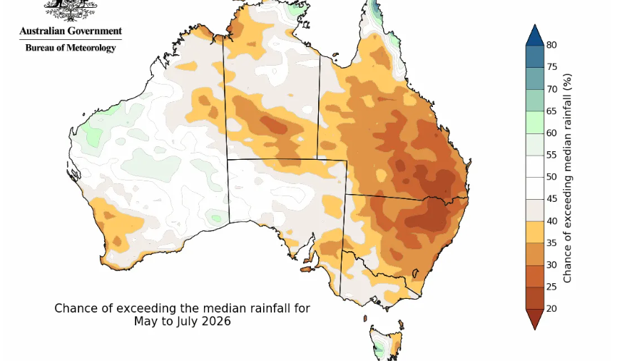
The current long-range forecast for May to July 2026 (issued 23 April) indicates:
- Rainfall is likely to be below average across much of eastern Australia and parts of south-west Australia.
- For most other regions, there is no strong indication towards either wetter or drier conditions, meaning there are roughly equal chances of above or below-average rainfall.
- May marks the beginning of northern Australia’s dry season, when much of the tropical north typically receives very little rainfall, aside from parts of the east coast of Cape York Peninsula.
What does this mean for rainfall?
While there is an increased chance of below-average rainfall across parts of eastern Australia between May and July, a range of outcomes are still possible. The Bureau cautions that autumn forecasting carries a higher level of uncertainty due to the well-known “autumn predictability barrier”, meaning confidence in ENSO forecasts generally improves later in the year.
Overall, the Bureau encourages Australians to stay informed through regularly updated seasonal forecasts, rather than reacting to speculation surrounding a possible “super El Niño” event.
Disclaimer: Forecast information in this article has been sourced from the Australian Bureau of Meteorology (BOM) and is shared by ABGC for general information purposes only. ABGC accepts no responsibility for the accuracy of the information or for any decisions made based on it.