The success of the map relies on the participation of banana growers who are being asked to contribute by putting the location and extent of their banana plantations into a land use survey app.
A first of its kind for the banana industry, the mapping will provide a national baseline for all commercial (>1 hectare) plantations in Australia.
The project is a partnership between the Australian Banana Growers’ Council, Hort Innovation,
the University of New England (UNE), Central Queensland University, Tie-up Farming and government.
Craig Shephard, Senior Researcher with the Applied Agricultural Remote Sensing Centre (AARSC) at UNE, said banana growers held the key to ensure the banana map was as accurate as possible.
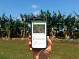
Growers can access the land use survey app here: une.edu.au/landusesurvey
To participate, a grower drops a point on the map (or searches for an address) to share the crop location and identifies the crop type, in this case bananas. There is an option to provide more information in a text comment and/or attach a photo.
The new point is reviewed and compared to imagery and, if accurate, it’s digitised as a banana plantation in the map.
The banana map builds on a map of commercial avocado, macadamia and mango orchards, developed and launched in 2017. This map has been viewed over 23,000 times and was applied in response to the recent bushfire crisis in Australia.
Mr Shephard said the banana map could be applied in a number of different ways.
He said containment strategies for pests and diseases including Panama TR4 stood to benefit from a more accurate understanding of the number and location of banana plantations.
“Knowing the distribution and extent of crops has the power to greatly inform decision-making at farm and industry levels,” Mr Shephard explained. “Applications include increased biosecurity preparedness, where targeted field surveys and the implementation of exclusion zones can immediately be implemented following an incursion, saving both time and money.
“For the industry, knowing the spatial distribution of crops greatly assists with a better understanding of demographics (i.e. regional forecasting), whilst a more accurate measure of a production area can assist with improved estimation of annual production.”
Mr Shephard said field work associated with developing the map started in North Queensland in late 2019.
“As remote sensing scientists, we observe things from afar, so we need to ground truth the data that is provided,” Mr Shephard said.
“In some way ways, growers become our ground truth.”
The mapping adheres to national standards for commodity level land use mapping, supported by the Australian Collaborative Land Use and Management Program (ACLUMP).
ACLUMP promotes nationally consistent land use information. Privacy concerns are acknowledged and respected as the information sources used to compile land use include remotely sensed data (imagery), state and national ancillary datasets, field observation and expert opinion.
No personal or confidential information is collected as part of the land use mapping process nor contained within the land use datasets.
This project is funded via the Australian Government’s Rural R&D for Profit program and through co-investment from partners; Hort Innovation, Central Queensland University, University of New England, ABGC, the Queensland Department of Agriculture and Fisheries and the Northern Territory Department of Agriculture and Resources.